Day 2 Cape to Cape by Sea (Written on June 02, 2013)
When I come on at midnight we are 30 nm WNW of Cape Naturaliste, just north of the northern-most cape in the south-west Cape region. We have three vessels accompanying us south as we all travel the continental shelf where the 200, 300, 400 and 500m contour lines lie parallel on a North/South axis. This is where the Leeuwin Current is running strongest with a southerly set of 2.5 knots! In the maritime world wind direction is named as to where it is coming from, so an Easterly wind is from the East. Currents, however, are named for where they are going to, so a southerly set current is going to the south. On one of the wheelhouse computer screens we have the daily current chart for the SW coast and thus we are aiming to catch the best possible ride with the Leeuwin Current (coloured red for fast!) which incredibly flows all the way to Bass Strait! With a “just off the head” breeze of a 30 knot South-easterly, we are making 8.0-9.3 knots of boat speed! Unbelievable! By 0035, the last of the three ships, Sonia will pass us with a CPA (Closest Point of Approach) of 4.2 nm. Now all I can see are stern lights slowly fading ahead of us…
The ride is jittery and unfortunately just before my watch a square wave made a few books stored in a beside shelf bop Curt on the head, waking him with a very unpleasant start. I don’t think this is called the Booker Prize but I do know he certainly wouldn’t have been handing it out! Perhaps, he would if it was a book to the side of the head! I am glad to say our bookshelf has been the only part of the boat that so far has proved un-Southern Ocean-proof…
Its’ a black night out and with the anemometer sitting on 30 knots I can see the horizontally spread white foam of the waves brightly lit by the lights of the main saloon. We take occasional white water over the bow which is seen as two semi-circles of whiteness arching away behind the foremast. Interestingly and effectively, the aft side of ships’ foremasts are painted matt black, otherwise white would be too reflective during night-time navigation.
A less than half moon gets my attention while lingering at the horizon abeam like the tips of a giant, orange Gouda wedge. Puzzlingly, upon “rising” the moon also appeared like humpback whale tail flukes aglow as a warm fire. This is an image that one never sees, so the likeness is totally unrealistic but the shape was slightly similar to a tail-sailing humpback whale!
At 0800 when I surface after a lovely sleep we are 16 nm from Knobby Head and 20nm from Cape Leeuwin. All around is a grey, molten sea with heavy cloud but patches of golden light manages to stream through. By 0930 Cape Leeuwin bears 070 degrees at 13.2 nm. This is the most south-west point of Australia and thus we have begun our circum-navigation. Now the sun peeks through a major gap in the clouds and the landmass of the southwest appears as a dark blue strip on a bright blue sea dotted with dancing white-horses. In the dense, black cloud mass above, thin parallel yellow lines of sunlight tease and on the water the sun-glare is an intense silver, crinkly almost impenetrable covering.

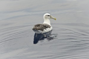
A Shy Albatross resting on the water – it’s wonderful to be in the presence of albatross again! Photo credit M.Jenner
Albatross soar by the bow and then to the stern. In our ten minute “Bird Observations” on the half hour every hour, the first birds “officially” observed are two Black-browed Albatross. Ducking and weaving across the waves and using the wind effortlessly – it is great, no fantastic to be in the presence of albatross again!
By noon when I come on watch, (after a morning of observing and quickly assembling lunch of salad, baguette, ham, salami and yummy cheeses) we have completely rounded Cape Leeuwin. The wind and sea, now only 20 knots and a 1m chop are similar to the conditions this morning. However, somehow there is a “big ocean feel” in this waterway. We are reminded we are entering the Southern Ocean by way of random square waves that shroud the bow in billowing spray – the moisture forming a prism of an intermittent and momentarily, beautiful rainbow arc right beside the boat.
Out on deck to identify a small petrel I can feel the wind is chilly and clearly there are icicles on the breeze! By 1415 it is becoming calmer, only 15-18 knots, this is very suitable cetacean observing weather. We have our eyes peeled. We are travelling along the 100m contour line paralleling the coast from Ledge Point to Point D’Entrecasteaux, the land of which appears as a thin, purple-hued line gently broken by creamy/yellow sand-dunes. Indeed the chart rightfully informs of places named Meerup Dunes, Dunes, Sandy Island and Sand Patch. This is REAL sand-groper country!
The 100% cloud cover gives way to grey, grey seas and despite looking and looking for cetaceans, the sunlight fails before finding any. With the fading light some layers of the cumulus clouds become tinged with pink, however the sunset is an absolute fizzler…The comforting “clack-clack-clack” of veggies succumbing to the knife welded by Resty on the chopping board remind us that our favourite Oriental Express and Beef Tagalog are on the menu for our evening meal! Yum!
Thus far the three bottlenose dolphins seen while leaving Challenger Passage are our only cetacean sightings. This will change soon I am certain!
From 50nm east of Denmark,
Mich


No comments yet.