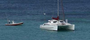
RV Whalesong
November 1, 2004- S 21° 30.0′ E 114° 02.0′
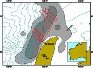
WhaleSong is currently surveying off Tantabiddi on the west side of North West Cape, Western Australia. CWR is conducting a series of vessel base surveys for BHP Billiton Petroleum and Woodside Energy as part of a cooperative strategy to collect baseline data prior to potential development in the area. Both companies permitted lease areas overlap portions of the humpback whale, and possibly blue whale, migratory areas creating a need to more fully understand the dynamics of these populations from season to season.

Map showing CWR survey tracks used off North West Cape to monitor the migratory movements of humpback whales. Grey shaded area represents the main migratory corridor at peak season as measured by CWR aerial surveys in 2000/2001.
At the moment we’re based off Ningaloo Reef, Western Australia, monitoring the humpback whale migration past a series of off-shore oil leases. The work is funded by Woodside Energy and BHP Billiton Petroleum as part of their requirements for Australia’s EPBC Act (http://www.deh.gov.au/index.html)
CWR initiated the study in 2000 as part of an EIS (Environmental Impact Statement) that Woodside was preparing for the federal government prior to seeking approval for anchoring an FPSO (Floating Production Storage and Offloading) facility near the 500m depth contour. Originally carried out as a 12 month series of dedicated aerial surveys recording all mega fauna species, the program continued for a second 12 months, providing scientists and the federal government with an excellent start to understanding basic mega fauna distribution and abundance in the area.

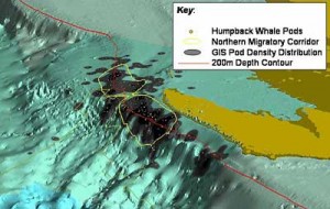
A three dimensional view of the humpback whale northern migration path near North West Cape Western Australia. Plot is generated from aerial survey data over a 2 year period.
Now in our fourth season of baseline data collection, we’ve switched from aerial surveys to vessel based surveys. The aerial surveys allowed us to create some very accurate migratory path models for the North West Cape region which we would like to be able to duplicate, and add detail to, with vessel surveys. If this is logistically and statistically possible we will be able to economically test this model at various locations along the WA coast where management blindspots currently exist. The more areas we test and fit to the model, the easier it becomes to predict the spatial and temporal boundaries of humpback whale migration all along the Western Australian coast. It’s almost like joining the dots!
Not only humpback whale movements are of interest to the CWR or management bodies. We also map positions of all encountered cetacean species so that critical habitats for many species will gradually become known.
Off the shelf break last week, for the first time in Western Australia, we sighted a pod of approximately 50 pan-tropical spotted dolphins (Stenella attenuata) and had a possible sighting of a single southern bottlenose whale (Hyperoodon planifrons). These sorts of rare sightings and identifications are not usually possible from aircraft traveling at survey speed (120 knots) and strengthen the argument to survey areas by vessel.
Later this season we will trial an assortment of drifting and towed passive acoustic arrays as a means of augmenting the visual surveys. Stay tuned for updates as to which systems work best!

