Ranging at Thistle Island – 19th C History unfolded (Written on Feb 26, 2013)

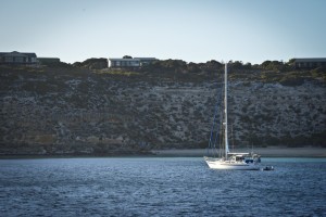
At Thistle Island, Whaler’s Bay is a desirable north facing anchorage surrounded by interesting holiday homes.
Photo credit M.Jenner
As we approach Thistle Island, South Australia, I asked Dale what the name of the water was between the island and the mainland. On closer inspection of the chart we realise this waterway is unnamed but there are many other names in the area with great importance. A history lesson unfolds as Dale shares information from a current book “The Great Race” which outlines the competition between the British and French explorers in the early 19 the century in their bid to claim victory for their countries in terra australis.
In 1808, while Joseph Bonaparte was in power, Captain Baudin was adventuring the high seas aboard Le Geographe for his homeland France. Captain Matthew Flinders, the more successful of the two, was also travelling and mapping undiscovered regions of our southern land with his ship Investigator. A chance encounter between Baudin and Flinders occurred not far from Kangaroo Island, whereby these two voyage Captains discussed and shared information, despite being “rivals” in the discovery game. Two such meetings were held, on an afternoon and the next day and where the two vessels were anchored near one another for these discourses, Flinders named this place Encounter Bay, situated at the eastern end of the Fleurieu Peninsula at the mouth of the Murray River . Both explorers were in the region to prove or disprove a then current theory regarding the presence of an inland waterway separating the land into two islands, New Holland and New South Wales. Ironically the enormity of the Murray Darling Basin was not discovered until over 20 years later, despite both men being here and looking for such a waterway. It was thought at the time that the Gulf of Carpentaria was the northern part of this water way and that Spencer Gulf would be the southern entrance. Indeed Spencer Gulf extends 160 nm to the north but as we know, does not separate our country in half.
The history lesson on the chart continues in earnest. Why do we need novels? Great material is there flat-out on the chart table. Six years earlier, in 1802 on February 21st, Captain Flinders sent his First Mate and friend, John Thistle, and seven others in the ships’ cutter, in search of water to replenish supplies aboard Investigator. While seeking water between the mainland and the island, sadly the men were never to return. The next day upon searching – no signs of the missing men were found. On the third day their wrecked cutter, an oar and a water keg were recovered from a nearby beach and it was deemed perhaps tidal rips had caused the unfortunate event. Captain Flinders named the point Cape Catastrophe and the largest island, Thistle Island, in honour of his lost friend. Several other islands in the vicinity he named Taylor, Williams, Smith, Lewis, Hopkins and Grindal, memorialising the other lost crew members.
For 30 years or so the island was by and large deserted and the earliest record of “residents” was in 1831 when an ex-convict from “Van Diemans’s Land” (Tasmania) and his two wives were found there by Captain John Hart. In 1838 the South Australian Company set up a whaling station on Thistle Island, however, the yield was too low to warrant further development and in 1840 it was shut-down after the men complained of “starvation and rotten beef, and biscuits such as hungry pigs would loath!” Some remnants of this by-gone era persist, particularly in the aptly named Whalers’ Bay.
In 1962 Theo Modra took possession of the island and made it a viable sheep-farming prospect. Today homes are perched atop the cliffs over-looking beautiful Whaler’s Bay. Many seabirds occur including wedge-tailed sea-eagles, osprey, oyster catchers, curlews and blue penguins. Two colonies of Fur-seals and a Sea-lion colony exist and the rare Pearson Island Wallaby population is thriving after recent introduction. The most notable are the animals not present on the island. There are no snakes, rabbits or foxes, which has led to the success of the native populations.

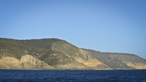
Interesting erosion of the geology of Thistle Island appear as “elephant’s toes” at the water edge.
Photo credit M.Jenner
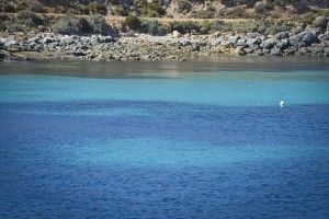
The sunrise, a huge ball of goldenness rising just beside Horny Point is gorgeous viewed from our anchorage tucked inside Whalers Bay. The orange hues lighting the “elephant toes” accentuates their rounded shape and scrubby vegetation hill-side. Bright sun-light on the calm water reveals bright, blue turquoise patches in amongst the dark-blue seagrass beds. Edges of the homes are lit with increasing sunshine and a yacht swings at anchor catching the warming sun portside on their white hull. This is spectacular scenery and a stunningly, sheltered bay. I can imagine the whalers seeking respite here from the bouncy Southern Ocean.
For the best part of 4 1/2 hours, Curt and Dale drive Whale Song over the range under different engine configurations for Benny (from Defence) and Rodney (from L-3) to record our acoustic profile recorded on the underwater hydrophones and from processed within a sea-container atop the cliff, just south of Horny Point.
While we drive in lines and turn neatly working our way through the ranging runs with short radio conversations to the hill-top sea-container, the main saloon on board Whale Song is an array of computers and girls working on the data we have collected in the last 8 days. The banter is intriguing “I’ve got pilot whales, then some sperm whale foraging calls, what do you think this blob is?” “Check the frequency range and what’s the call duration?” “Oh, here are the aliens again!” “Hey, what date were those tuk-tuk fish?” “On the 24th investigate those blobs, they could be krill swarms” “Bio-duck is in the PASOR grabs and the ISHMAEL takes has those three blue call types from the other day”. No nail polish and girlie talk here, it’s all about frequency, ranges, call duration, mat lab algorithms and spectrograms…
All goes well with the ranging and after 29 runs at 1525 we make a north-westerly course for Port Lincoln. Port Lincoln, the nearest town from Thistle Island (40 km away) is named after the English hometown of many of the crew of Investigator, Lincolnshire. This seaside town has a population of 13,500 people and is the heart of the tuna fishing industry being world-renown for aquaculture innovation.


No comments yet.