Day 11 Bouncy Bass Strait! (Written on Jan 29, 2013)

View from the foremast of the researchers at work.
Photo credit M.Jenner
Thoroughly getting into the groove of my midnight watch I have been naturally waking five minutes before Resty’s gentle knock-knock-knock on our door. The soft light of the highly appointed moon fills two port windows of the wheelhouse. Almost immediately upon deployment of the sonobuoys at 00:10:46, “whistles” in the shape of half rounds like a cupped hand squiggle on the Ishmael screen between 8,000 and 10,000 Hz. Maria and I madly take Ishmael and Pasor grabs adding to the huge gallery of wonderful heard and seen sounds we have collected in the last week and a half.
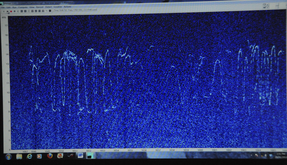
High frequency dolphin whistles captured on Ishmael.
Photo credit M.Jenner
Gazing at the array of colourful screens I remember the data techniques used for humpback whale song research thirty years ago. The tools available now on board our good ship Whale Song are light years ahead of the printed paper sonograms previously employed for bird and cetacean song analysis. The signals seen and recorded in each 24 hour period are important on many levels, namely, exploring the actual properties of the sound and the implications of presence of those species for Australian conservation and management.
Twenty-four nautical miles south of Cape Liptrap we are in the middle of Bass Strait. Two vessels ahead of us, shown by their AIS signal on our on the nav computer, are headed to the east coast as well. We are moving in a designated shipping laneway which separates west and eastbound vessels. Traffic heading eastwards is directed by arrows on the chart to be south of interestingly named places such as Forty Foot Rocks, Rodondo Island and W. and E. Morcoeur. Cutter Rock, Devil’s Tower and Crocodile Rock, non-inviting spots encourage the mariner to steadfastly maintain the shipping lane.

Deploying listening sonobuoys, collecting the sounds of the sea.
Photo credit M.Jenner
The wind is 22 knots from the SW as we trundle along under the moonlight listening for whistles. Surely, I am in heaven. Our day with common dolphins was wonderful yesterday and again today we have had another seven pods. Common dolphins find you – they are attracted to vessels and actively play in the bow and stern wash for hours or even days. This mild character flaw, inquisitiveness, however, sadly is their un-doing and makes them vulnerable to any form of net trawling. Maintaining genetic diversity of distinct population groups in Australian waters is a priority. Skipper had such a fun day racing up and down the decks with the dolphins alongside, most of the day and as such he is absolutely exhausted at day’s end and glad for the chance to rest.
Approaching South Point I remember fondly this gorgeous rugged coastline which we had the pleasure of visiting last summer while assisting colleagues at Flinders University, Adelaide with genetic research on common dolphins. Thinking of “land-ahoy and all”, King Island made a lovely entrance at stage right yesterday with its’ rolling hill landscape and the gleaming lighthouse of Cape Farewell visible during the day as we travelled east. This morning the lighthouses on McHugh Island in the Glennie Group and South East Point near Wilsons Promontory, glow brightly in the darkness and flash bravely.
In the portside window I can see an extremely large dark shape looming, but I know we are not in danger… Checking the chart, this is indeed Wilsons Promontory. Mt. Oberon at 753 metres above sea-level can be seen clearly in the moonlit glow. Around nine am, some of the acoustic and visual crew whom are from nearby locales, are excited about my description of Wilsons Prom rising out of the night sky like a great slumbering dinosaur. They ooh and aah thinking about The Otways which we passed yesterday and reminisce about Australian fur seals and Short-tailed shearwater field research seasons spent near Skull Rock and Kanowna Island near the southern tip of Wilsons Prom. It’s nice to hear the girls’ closeness, affection and connection with their local land-marks.
At 0939 we are 57 nm south of Lakes Entrance, Victoria. On deck, we look and look and look and already two pods of 50 and 4 Short-beaked common dolphin bow-ride. Today we have seen a few more Australasian gannets, Common diving petrels (complete with insulting bird book description “a tubby little blackish petrel with short, stout bill, short tail and dusky white under-parts and under-wings”) and pretty prions.
With a SW wind of 18-20 knots behind us, the ride is comfortable and despite the grey it is not too cold on deck, but hot tomato soup packed with veggies seems appealing. A huge pot is prepared and heated spring rolls and fried rice nicely compliment each other. The mid-day acoustics deployment reveals scores of dolphin whistles with “tick” marks and swirls covering several thousand Hertz. Indeed, nine sightings of common dolphins means we hear their signals most of the day as well as seeing multiple large pods bow-riding.
Whale Song is travelling along nicely heading NE. Purple marks dot the navigation chart – the evidence of the NE Bass Strait oil/gas activity. Twenty-one facilities labelled with fish names such as Snapper, Marlin and Mackerel, are scattered from the seaside towns of Seaspray to Conran and clustered from the coast to the 100 metre contour, to 45 nm offshore. The chart indicates we will soon leave Bass Strait and enter the Tasman Sea. Hey, Tas this is your place, a wonderful mix of the waters between NZ and Oz!
“Securite, Securite, Securite, this is Coast Radio Hobart…” crackles the VHF. We really are on the east coast, and sadly our journey will be complete in a couple of days. All afternoon in steel-grey seas and overcast skies we trundle along. The seas are confused, swell from the E and SW and wind from the SW at 23-25 knots. Our track-line follows a canyon of 2194, 2505 and 2414 metres, which we cross at 1530. We scan and scan but unfortunately detected behind us on the sonobuoys, sperm whales forage in the deep water and Southern right whale “pulses” cover the screens of Ishmael, Pasor and Sonix. Just at 1835 a Minke-like whale body is sighted by Maria and as we stop and deploy sonobuoys, 5 Albatross circle with 15 short-tailed shearwaters and another pod of 15 common dolphin swings by to the delight of Skipper! Surely, this is a productive area with all this wildlife concentrated here.
Ukelele tunes will transport me to a palm-fringed tropical island – quite different from the current vista of grey sea and grey sky. Dinner altogether, instead of the usual two seatings at 1830 and 1900, is a time to discuss the day’s events with delightful dolphins all around again and the proceedings for the next couple of days including our arrival at Jervis Bay, NSW. Tomorrow, Wednesday (I believe), will be the last full day of survey as we will make land-fall at JB on Thursday, January 31, 2013.

Short-beaked common dolphin (Delphinus delphis) leaping across the waves towards ‘Whale Song’.
Photo credit M.Jenner
The Marine crew have done extremely well keeping our good ship Whale Song running smoothly and the Science gang working extra hard with the visual and acoustic observations. It has taken great effort by all the crews to maintain concentration looking from dawn until dusk and listening four or five times each day. This has definitely been a fantastic team event! AWESOME WORK EVERYONE! Whale Song and her crew rock!
From the “South Pacific” (!),
Mich


No comments yet.